|
Current Version: Download MapLogic Layout Manager and use it for FREE. |
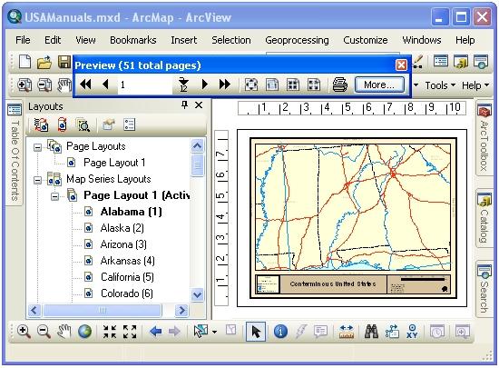
- Map Series - Maps that are broken into multiple pages
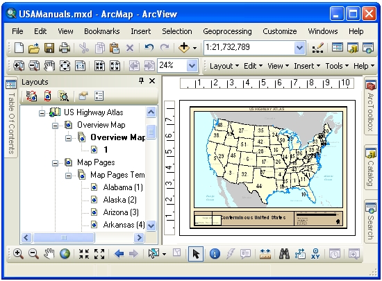
- Locator Maps - Overview maps that highlight the location of the current page in a series
- Key Maps - Overview maps that lists the page number where you can see the detailed map of an area
- Indexes - Listings of map features the pages they are located on
- Series Text - Text that changes from page to page
MapLogic Layout Manager is an extension to ArcGIS which provides all the tools necessary to create and print multiple page layouts, map series and map books within ArcMap. ArcMaps cartographic tools were designed to create very sophisticated individual maps. MapLogic Layout Manager was designed around the concept of multi-page maps. However, MapLogic Layout Manager does much more than just break up a map onto multiple pages. It handles all the details necessary for creating a true multi-page document just like your standard word processor will. Things like page numbering, indexing, two-sided printing, print previewing are all automatically handled by MapLogic Layout Manager.
As part of creating map books, you will be able to make:
MapLogic Layout Manager brings all the parts of a map book together in a single product. Each part of the book is aware of the other parts. For example, if you insert new page into the book, all the page numbers are automatically corrected, the map key will automatically update itself, the listings in the index will correct themselves to accommodate the new page and so on.
![]() MapLogicLayoutManager_SampleBook.pdf (5 Mb) - Click here see a sample map book created using our
extension. This book highlights some of the key features of our product. If you'd like to evaluate
the extension for 30 days, follow the download link at left.
MapLogicLayoutManager_SampleBook.pdf (5 Mb) - Click here see a sample map book created using our
extension. This book highlights some of the key features of our product. If you'd like to evaluate
the extension for 30 days, follow the download link at left.
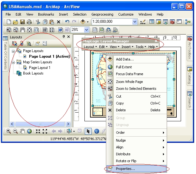
- The Layouts Table of Contents
- The MapLogic Layout Manager toolbar
- The properties of different layout elements and data frames
MapLogic Layout Manager seamlessly integrates with ArcGIS. Everything you need to get to in order to use the MapLogic Layout Manager extension is in one of three locations:
Map Series Frame
A map series frame is how you display areas of the map in and map series (similar to a data frame). However, unlike a data frame, a map series frame knows how to break the map onto multiple pages using the contents of a special polygon layer called the index layer. For example if your index layer is breaking your map into 20 pages, the map series frame will make the layout 20 pages long.
Series Key Frame
A series key frame is used to create key maps. A key map is an overall map of the area in the map book showing what page the details for each area of the map can be found. For example, you might want a map of the entire United States at the beginning of your map book showing the page number where each state can be found. A series key frame was designed for this purpose.
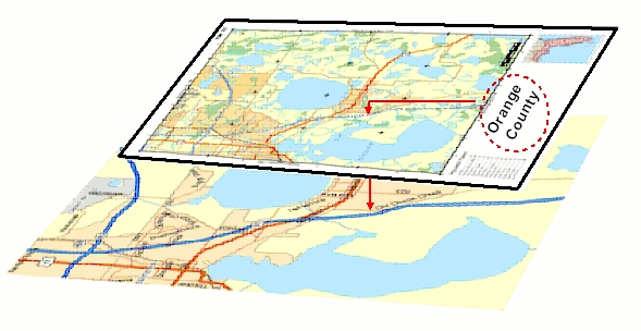
Series Locator Frame
A series locator frame shows you which part of the overall map is being displayed on the current page. For example, if you create a map book of U.S. States, you might want a small map of the entire United States on each page highlighting the location of the state that is currently being displayed. A series locator frame is designed for this purpose.
Detail Frame
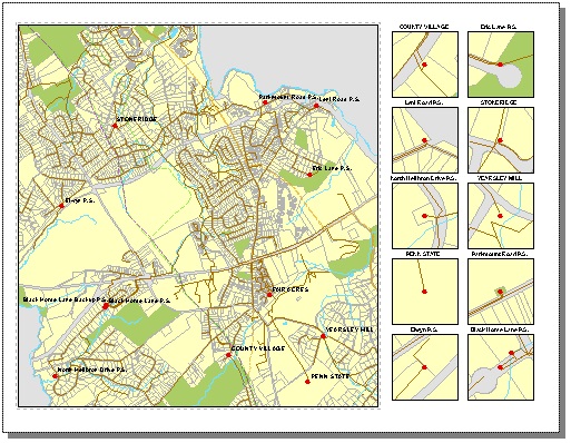
A Detail Frame is an area set aside on the layout for detail maps. Detail maps are created based on a user-selected layer. As the map moves from page to page, the detail frame will examine the layout to see if features from the selected layer are present on the visible extent of the map and automatically generate detail maps highlighting the location of the features.
The detail frame is not the same as a single detail map. The detail frame represents and area on the layout that is reserved for detail maps. The detail frame will fill this area with as many detail maps as there are detail features in the visible extent of the map up to a maximum number that will fit within the boundaries of the frame. The heading, size, scale and layers present in the detail maps are all parameters that are set by the user.
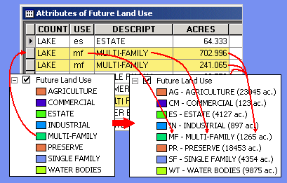
Legend Symbol Labeler
The Legend Symbol Labeler is designed to make it much easier to create custom legend labels based on the data contained in the attribute table of a feature layer in ArcMap. Instead of having to create a summary table and then manually type the results into a layer's legend, you can now automate the process by creating an expression for the labels.
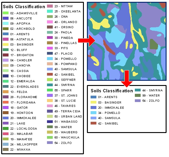
Dynamic Legend Element
The Dynamic Legend element creates a subset of an ArcMap legend so only those symbols appear in the legend that are within the visible extent of the map. The Dynamic Legend will examine each item in the ArcMap legend and then check the map to see if there is a corresponding feature within the visible extent of the map. If a map feature is found then, then the symbol is included in the legend. If no map feature is found, then the symbol is not displayed.
Dynamic Legends work with single symbol, unique value, graduated color and graduated symbol legends.
Series Text Element
A series text element is used to create dynamic text on the pages of a map book. For example, if each page of a map book is showing a unique section, township and range, you may want to create a text box that shows what the section, township and range values are on each page of the map book. If you have this information in your index layer, you can use the series text element to create a text box that dynamically lists this information from page to page.

Geo-Text Element
Geo-Text is similar to the Series Text element in the sense that the text element gets refreshed as you move from page to page in a series. However, unlike the Series Text which could only extract information from the attribute table of the Index Layer (grid layer), the Geo-Text element can extract information from any layers attribute table.
For example, suppose your map series moves over a number of different municipalities and you would like a label on your map layout showing the name of the municipality you are currently on. With the Geo-Text element you can link the text label to the municipality layer and extract the name and place it as a label on the layout.
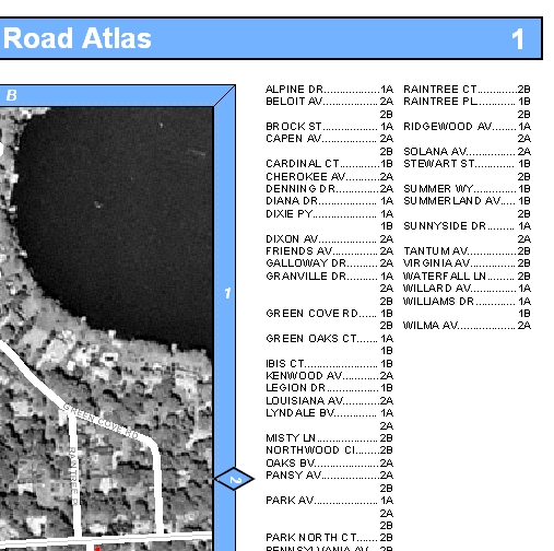
Page Index Element
A Page Index Element is used to create indexes of features on the current map page. For example, if you are creating a road map book, you may wish to have a listing of where each road can be found on each page of the map book (for example, Main Street .B4). A Page Index Element must always be on the same layout as the map.
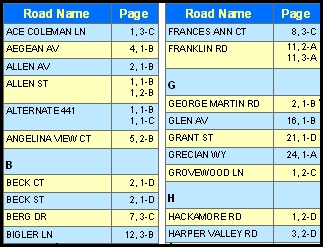
Series Index Element
A series index element is used to create indexes of features on your map pages. An index is an alphabetical listing of feature in a map book and where they can be found. For example, if you are creating a road map book, you may wish to have a listing of where each road can be found in the map book (Main Street .Page 2 B-4). Depending on how many listings there are, a series index element can occupy one or more pages.
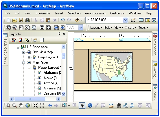
The extension adds a container to the ArcMap document (Mxd) where it holds layouts, map series and map books. The contents of this contained are displayed in a new window called Layouts in ArcMap.
Can a user who does not have the MapLogic Layout Manager extension open an ArcMap document that has been modified by the extension?
Yes. We have designed the extension so that it will allow the Mxd to be opened on other copies of ArcMap whether the extension is present or not.
What will ArcGIS users who dont have the MapLogic Layout Manager extension see when they open an ArcMap document modified by the extension?
The user will see the layout that was active when the ArcMap document was last saved. However, keep in mind that the MapLogic Layout Manager has a free Viewer license level, which allows the user to move around the layouts and preview (but not print) map books.
MapLogic Layout Manager has 4 different license levels; Viewer (free), Basic, Advanced and Pro. Depending on the license level that you have purchased, you will have different tools and capabilities available to you. For more information about what you can do with each license go to the license information page.
Download MapLogic Layout Manager
MapLogic Layout Manager is a free product.